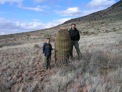
Barrell cactus
Chris & Ansel pose with a barrel cactus at Rockhound State park, near Deming, New Mexico.
posted by Chris Koehn at
9:53 PM
|
1 Comments
![]()
posted by Chris Koehn at
9:53 PM
|
1 Comments
![]()
posted by Chris Koehn at
9:51 PM
|
0 Comments
![]()
posted by Chris Koehn at
9:49 PM
|
0 Comments
![]()
posted by Chris Koehn at
9:46 PM
|
0 Comments
![]()
posted by Chris Koehn at
9:44 PM
|
0 Comments
![]()
It’s February 11 and we’re at City of Rocks State Park New Mexico for the last day. City of Rocks gets its name from the bizarre volcanic rock formations that jut out of the desert, which from a distance gives the appearance of a skyline. The rocks are a boon for the boys, as there are countless holes and hiding places to explore. We leave for Tucson tomorrow. It’s raining here in the desert, which does not jibe with our plans. When in the desert in the winter one hopes for dry weather, as there is little to do inside, as there are few “insides” to be had in these parts. Fortunately the Stoddards are here. We met Harry and Sylvia and their 5 kids while on Padre Island last month. Our kids and their kids can entertain each other- or at least have someone new to fight with... Cabin fever is beginning to set in and we just want to get through today and tomorrow’s drive, as the forecast after that is clear for a few days.
I’ll pick up where I left you a few days ago- leaving Big Bend. We drove north from the park to Fort Davis and the Davis Mountains State Park. The Davis Mountains are one of a series of small west Texas mountain chains formed 100,000,000 years ago by volcanic activity. The geology of these mountains as well as the Chisos in Big Bend is similar, in that magma pushed it’s way to the surface with varying degrees of assertiveness. In some areas it’s clear that the eruption was cataclysmic; in others the magma slowly lifted the sedimentary rock above- laid down by an ancient sea- creating areas where the layers of rock jut up at unexpected angles, with magma bulging out where resistance was least. The color and composition of the magma is strikingly different from place to place as one wanders across the mountains. I hope that Ansel will retain some of what he’s learned about geology here. This must be one of the best places in the World to learn about the earth’s history experientially. Ansel And I did a very difficult mountain bike ride at the park as well. This is a sport he seems to have a natural aptitude for and a healthy interest in. It’s a great way to get exercise, see the country (albeit blurred some times), and beat the heck out of our bikes.
One of the things that drew us to a stop in Fort Davis was its proximity to the McDonald Observatory. The observatory was located here for the site’s optimal combination of altitude and distance from city lights. One of the advantages to camping in remote west Texas is the spectacularly dark nights. Unfortunately the night we chose to visit the observatory (and the only night they were open for viewing that week) it was cloudy. The staff rallied and put on an indoor presentation, which was informative, but not as good as the real thing. We’ll have to try again at another observatory further west. Any recommendations? Please E mail me at chris@koehn.com. Thanks!
While in Fort Davis I had the speed sensor on the truck replaced. It failed the day we drove in to Big Bend, and the speedometer hadn’t worked since. If one were to choose a place to have a speedometer fail it would have to be west Texas, as the one pick up you meet on the road per hour doesn’t seem to give a hoot how fast your driving anyway. A garage was recommended in Fort Davis that is run by a retired racecar driver. Blake surprised me with the high quality service he provided. In fact, with the exception of the Ford dealer in Corpus Christi (hack, spit) everyone we’ve looked to for service has been fair and (for the most part) competent. $90 and two hours later we were back on the road.
We drove north through the Davis Mountains on a scenic state highway to Interstate 10- the main east-west route in these parts. 10 is a blur of heavy trucks and RV’s and I prefer the “blue” highways, but in west Texas sometimes the road options are very limited if a 200 mile detour isn’t in the cards. We’re skirting along just north of the Mexican border on the way to El Paso, where I have “O” rings waiting at a Camping World store to complete the under counter water filter I’ve been trying to get operational since purchasing it near San Antonio. El Paso is a sprawling city and it’s hard to believe only 400,000 people liver here- it seems to go on and on, spilling out forever. To the north of the freeway is retail hell (as Ruth dubs these places); to the south, across the narrow and muddy Rio Grande are the slums of Juarez, Mexico. Seeing the deplorable conditions there causes us to understand with greater depth why these people want to come to the U.S. so badly.
All along the Rio Grande valley are the first real agricultural fields we’ve seen in some time. First pecans, then crops- then mile after mile of factory dairy farm. Here they don’t even bother with barns; the cows look pathetic housed under small shed roofs standing in mud. Yet another reminder of the awful state of this industry.
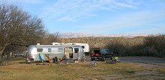
After a brief stop at Camping World we continued west on 10 in the rain. We got off in Deming New Mexico (FINALLY out of Texas!) and headed toward Rockhound State Park. Rockhound is a small park nestled in to the side of the Florida Mountains, and it is the only state park where rock collecting is allowed. We had a couple of days worth of climbing around on the mountains, looking for geodes and jasper, doing laundry and grocery shopping in Deming (hot peppers, tortillas and tamales rule here), and waiting for the Stoddarts to catch up with us. They also were having some mechanical difficulties with their RV. A blown catalytic converter stranded them near El Paso for a few days. Fixing vehicles while on such an odyssey seems to be a mandatory part of the experience.
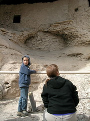
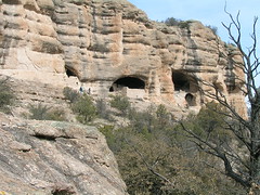
The Stoddarts finally did catch up with us at City of Rocks, arriving late in the day we chose to visit the Gila cliff dwellings. The Gilas are 60 miles north of here- a drive that takes 2 hours to complete. Shortly after leaving the Chihuahuan desert in which City of Rocks lies, we drove in to the Aldo Leopold Wilderness and the Gila National Forest. The road, while steep and twisted, offered fantastic views across this little used backpacker’s paradise. We crossed the Continental Divide trail along this route as well. Another place to revisit some day when the boys are bigger.
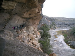
Geronimo was born along the banks of the Gila River some 600 years after the Mogdollon tribe built these cliff dwellings here in this sheltered, steep canyon. It’s fun to help the boys imagine what it must have been like to live in these deep sandstone caves in 1300 A.D. What did the kids do for fun? Where did they play? What did they eat? We have archeological hints, but no one really knows who these people were or what became of them. The dwellings were only inhabited for 30 years before the Mogdollon abandoned these well-constructed homes and left without a trace. We returned to our Chihuahuan Desert encampment after a few hours, tired from the 70 mile (each way) drive that took 2+ hours (each way), to find the Stoddarts had arrived. The kids immediately hit the rocks and we’ve seen nary a trace since. I hope they come around by the time we are ready to hit the road again tomorrow.
posted by Chris Koehn at
9:09 PM
|
0 Comments
![]()
posted by Chris Koehn at
9:06 PM
|
0 Comments
![]()
posted by Chris Koehn at
9:03 PM
|
0 Comments
![]()
posted by Chris Koehn at
9:00 PM
|
0 Comments
![]()
posted by Chris Koehn at
8:58 PM
|
0 Comments
![]()
posted by Chris Koehn at
8:32 PM
|
0 Comments
![]()
posted by Chris Koehn at
8:30 PM
|
0 Comments
![]()
It’s the 9th of February and we’re in City of Rocks State Park, New Mexico, near Silver City. We’ve been dodging along the Mexican border for the past several weeks: from San Antonio we traveled south to Padre Island in the gulf off Corpus Christi, then west to Big Bend National Park, then north to the Davis Mountains, west to El Paso, and after a month in the Lone Star State, we finally found our way out of Texas. Here’s a recap of the highlights Through Big Bend. We have to drive 30 miles for an internet connection here in New Mexico; hopefully it will be a bit more convenient once we reach Tucson next wee, and I'll complete this missive and add some pictures.
Our decision to head toward the gulf again was finalized after we encountered freezing temps several nights near San Antonio. Enough already- we need some warmth! And we weren’t disappointed. We could, without terrific discomfort, wear shorts for nearly the entire week we were there. Mustang Island S.P., on the northern tip of Padre, doesn’t offer much beyond a big beach. And that was enough. It was good to relax with no real pressing agenda for a while. We met a navy family while there. Dan and Sarah and their three kids choose to live in a trailer while Dan works at a nearby base. After moving many times they decided it’s best just to take their house with them. Our kids hit it off right away, and we arranged playtimes and pot lucks in short order. Next came Harry and Sylvia from Ontario in their RV with 5 kids. Now Ansel and Rainer were really in heaven, the potlucks grew, and friendships are begun.
Dan and Sarah asked for some ideas reconfiguring their dinette. Not being one to actually enjoy too much relaxation, I volunteered to build then a new fold-up dining table and a few shelves. We shopped for hardware and plywood in Corpus, set up a cabinet shop in the campground, and went to work. Harry chipped in. We worked hard (things always take twice as long as I figure they will- not a very good trait for a timber framer..) but had fun.
We did manage to see and do while there. The Padre Island National Sea Shore is fantastic. 50 miles of beach stretching to Brownsville, incredible birding, and ghost crabs to nip at every toe. We also took an excursion boat out of Port Aransas, in search of dolphins and other sea life. The two hour trip was billed as a scientific discovery and we weren’t disappointed. One of the fellas working on the boat set a small shrimp net and a smaller plankton net. After dragging them for a couple hundred yards, we pulled them in to examine the catch (which was later released). There were three stingrays, strange bottom walking fish, a bunch of shrimp, and all the plankton we could look at under hand help microscopes. And we did see a bunch of dolphins, which was icing on the cake.
After nearly a week on Padre we packed up and headed west. We did the drive to Big bend in two stretches- the first was ~300 miles, stopping for 2 nights at Seminole Canyon S.P. But alas, the best laid plans… at about 5:30 that evening I began to notice what I thought was the truck misfiring. We stopped to fix a quick dinner in the Airstream in Chorizo Springs. I checked what I could on the engine but found nothing and assumed I’d bought some bad diesel. When we continued our drive we made it no more than a mile before the trailer brakes locked up. I stopped the truck and discovered that we had been dragging the umbilical (the cable that supplies the trailer with lights and power while hooked to the truck) for quite a ways. It was worn down to a nub, and the wires inside were shorting out quite dramatically. But as luck would have it, we were 100 yards past a small private RV park. I duck taped the umbilical up, we did a “U” turn and parked it for the night. The park owner recommended a shop in the next town- Del Rio- 80 miles further on our route. I called ahead to the shop and they got us right in and fixed us right up while we had a nice Mexican lunch, shopped for groceries, and made a few calls. It is good to have one’s faith in humanity restored every once in a while (especially after paying a Ford dealer (spit, hack) in Corpus way too much to misdiagnose and fix the brakes on the truck). We made it to Seminole Canyon that night- a day late but none the worse for wear.
Seminole was our first real taste of the desert. We knew this by finding the cacti surrounding our campsite in rather unpleasant ways while unhooking in the dark.
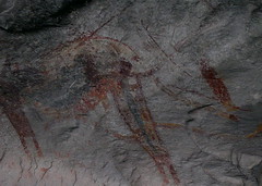
But the real attraction of this place is the canyon- or rather what some creative native Americans drew on the walls of the canyon a few millennia ago. One thinks of the Eastern U.S. as being the cradle of our civilization. Not so if these folks are given their due. They were here, living in harmony with the desert, communicating via these incredible symbols before the Egyptians were first experimenting with pyramid building. Columbus “discovered” America in 1492. The Spanish had settlements in these parts by 1530. There is much history in these wide-open places.
We got our first glimpse of the Rio Grande at Seminole Canyon. We were to follow it for the next two weeks along the Mexican border. The Rio Grande, which defines the border, cuts a narrow channel through 300 feet of limestone here. We thought this to be dramatic- and it was- until we saw the channel she cut at Big Bend.
Big Bend is one of the largest national parks at over 800,000 acres. It encompasses an entire mountain range (the Chisos) within its boundaries. And yet it is the least visited of all the national parks. This is due, I guess, to its remoteness. 250 miles from El Paso (the closest population center), 600 miles from Dallas, it requires a commitment to get here. The drive from Seminole Canyon was the first in which I filled the truck’s fuel tank at every opportunity, as with a 300 mile range, we could run out before we got to the next town if we made one wrong turn.
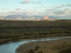
The park is named for the huge ox bow the river makes here- heading south, then east, then north- before resuming it’s south easterly meander to the gulf. We camped at the point where the river changes course from east to north, directly across from the Mexican Sierra del Carmen Mountains. This range presents a view of its sheer 2,000 foot cliffs to us gringos. The top of the cliffs- which appear level- consistently have clouds hanging on them and spilling over, giving the appearance of milk spilled from a huge table that somehow magically evaporates on its way to the river- some 7,000 feet below. At sunset the cliffs change from tan to pink to black. The campground comes to a complete stop while everyone watches this amazing show. Then the stars come out. Being hundreds of miles from any city makes for beautifully dark nights. If you never knew how the Milky Way got its name you need to spend a few nights at Big Bend.
We had met another family traveling with kids at Seminole. Kevin and Christine have 3 kids- two of which are very close in age to Ansel and Rainer. They have been traveling for 10 months with their “fiver” (fifth wheel) and dodge diesel dually and are on their way back to their home in Sacramento California- completing a full year on the road. We hooked up with them again in Big Bend. The kids built a fort, we shared a couple of meals, and did some hiking together. These kind of acquaintances really make this lifestyle fun. Ansel wants to visit his new friend Connor at his house. I bet we can arrange that.
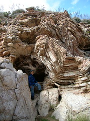
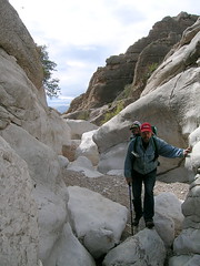
One day, while it was too cold to hike up in the high elevations of the Chisos, our family decided to go for a hike on one of the lower elevation mountains that crop up in the middle of the Chihuahuan desert. We drove on a four- wheel drive road across the desert to get to the trail head. The hike eastward over the mountain, while providing nice views and beautiful cacti, was otherwise uneventful. When we came down off the far side of the mountain we encountered a spot where a creek had cut a deep canyon through the mountain back west toward where we started our hike. Upon studying our topo map, it appeared as though a trail started up this canyon from the west, and that if we could pick our way through the first half of the canyon we could meet up with this trail- enjoying the unique geology, flora and fauna one finds in canyons here.
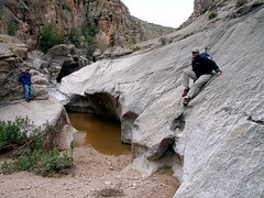
The first third of the hike was easy, hiking along the dry creek bed’s level gravel. Then we began encountering areas where the creek had cut through the basalt bedrock, creating beautiful organic shapes in the stone. The hiking gradually got more difficult, as we scrambled over this bizarre moonscape. Soon we found ourselves wishing we had brought a rope and climbing gear, for the pleasant hike along a gravel stream bed had become a descent through a full fledged slot canyon. But after a few challenging climbs along steep cuts the trail gradually opened back up and we soon found ourselves back out on the open desert. This was one of the most memorable hikes we’ve had on our trip to date. The beautiful shapes of the rock, the geologic history laid bare before us, the beautiful cacti- were nothing short of magical. For me this is what it’s all about.
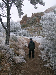
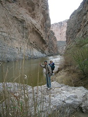
We did three more hikes while in Big Bend: one with a geologist into a canyon in which the volcanic history of this part of the park were laid bare; one to see the beautiful 1,000 foot sheer limestone cliffs that the Rio Grande cuts through the south eastern border of the park; and one up in to the Chisos mountains. We had waited until the weather cleared a bit before attempting a hike in these craggy peaks. When we left our camp, it was sunny and warm and the mountains appeared clear from our view 25 miles away. But when we got up in to the mountains- gaining 5,000 feet in elevation- we encountered clouds and snow. The hike was chilly, the views were less than spectacular, but the mountains shrouded in clouds and cactus covered in frost were magical.
Big Bend is a place with a strange magnetic attraction. Most folks don’t go out of their way to get to this place. It’s barren and inhospitable to those who refuse to play by Big Bend’s rules. But if one can learn to get along with the desert on her own terms she shows you glimpses of her beauty which leaves one wanting more. We’ll be back here some day.
posted by Chris Koehn at
10:10 AM
|
0 Comments
![]()

Subscribe to
Posts [Atom]